Search Constraints
You searched for:
Period 18th century
Remove constraint Period: 18th centuryAssociated Places North America
Remove constraint Associated Places: North AmericaSearch Results
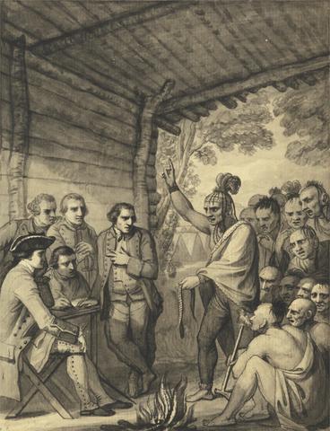
1
- The Indians Giving a Talk to Colonel Bouquet in a conference at a Council Fire Near his Camp on the Banks of Muskingum in America, in October 1764, 1765
- between 1765 and 1766
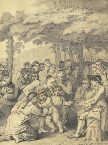
2
- The Indians Delivering up the English Captives to Colonel Bouquet near his camp at the folks of Muskingum in North America in November 1764, 1765
- between 1765 and 1766
3
- Twelve remarkable views in North America and West Indies
- [between 1771 and 1785]

4
- North America, and the West Indies
- [1764?]

5
- A voyage to North-America: undertaken by command of the present King of France
- MDCCLXVI [1766]
6
- A map of the British colonies in North America
- [1775?]
7
- A map of the British and French dominions in North America
- [that is, 1757]
8
- The Atlantic Neptune
- [1774-1800?]
9
- A map of the British Empire in America
- [ca. 1737]
10
- The English pilot
- MDCCLIII [1753]
11
- The American military pocket atlas
- [1776]
12
- Suite du Neptune françois, ou, Atlas nouveau des cartes marines
- MDCC [1700]
13
- A general map of North America
- [1762?]
14
- A map of the British and French dominions in North America
- Febry 13th, 1755
15
- A map of the British Empire in America, with the French and Spanish settlements adjacent thereto
- [1739]