Search Constraints
You searched for:
Associated Places Great Britain
Remove constraint Associated Places: Great BritainSubject Terms Great Britain -- Maps -- Early works to 1800.
Remove constraint Subject Terms: Great Britain -- Maps -- Early works to 1800.Search Results

1
- Britannia insula quae duo regna continet Angliam et Scotiam cum Hibernia adiacente
- MDLVI [1556]
2
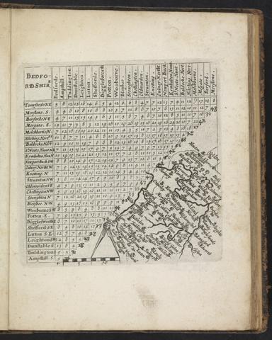
- A direction for the English traviller
- 1643
3
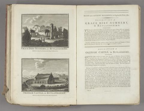
- Historical descriptions of new and elegant picturesque views of the antiquities of England and Wales
- [1786]

4
- The theatre of the empire of Great Britaine
- [1612]

5
- A new mapp of England Scotland and Ireland
- [1678]
6
- Cantabrigia illustrata
- [ca. 1700]
7
- The kingdome of England & principality of Wales
- 1644
8
- Britanniae insulae quae nunc Angliae et Scotiae regna continet cum Hibernia adiacente
- MDLVIII [1558]
9
- Illustriorum principumque urbium septentrionalium Europae tabulae
- [1657]
10
- The theatre of the empire of Great-Britain
- MDCLXXVI [1676]
11
- Theatrum Imperij Magnae Britanniae
- anno cum privilegio 1616
12
- The gentleman's guide
- [17--]
13
- Britania, or, A geographical description of the kingdoms of England, Scotland, and Ireland, with the isles and territories thereto belonging
- MDCLXXII [1673]
14
- Britania insula quae duo regna continet Angliam et Scotiam cum Hibernia adiacente
- anno MDLXII [1562]
15
- Britannia, or, A geographical description of the kingdoms of England, Scotland and Ireland, with the isles and territories thereto belonging
- MDCLXXII [1673]
16
- Les isles Britanniques, qui contiennent les Royaumes d'Angleterre, Escosse, et Irlande
- [approximately 1695]
17
- Magna Britannia, aut Anglia, Scotia et Hibernia, quarum prior divisa in septem Regna, sive Provincias, dictas Northumbriam, Merciam, Angliam Orient. Essexiam, Cantium, Sussexiam, Westsexiam, et Princi. Walliae. posterior in Septent. et Austr. Scotiam. postrema in quatuor Provincias Ultoniam, Lageniam, Momoniam, et Conagtiam
- [approximately 1705]
18
- A direction for the English traviller
- [1677?]
19
- Britanniae insulae quae nunc Angliae et Scotiae regna continet cum Hibernia adjacente nova descriptio
- MDXLVI [1546]
20
- A collection of plans of the principal cities of Great Britain and Ireland
- [1764]
21
- [Proof engravings for The theatre of the empire of Great Britaine]
- [circa 1610?]
22
- Map of Great Britain C. A. D. 1360 known as the Gough map
- 1958
23
- Blaeu's Atlas of England, Scotland, Wales and Ireland
- [1970]