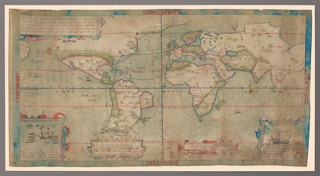
Vera descriptio expeditionis nauticae Francisci Draci Angli, cognitis aurati qui quinq[ue] navibus probe instructis, ex occidentali Anglia parte anchoras soluens, tertio post decimo Decembris An[n]o MDLXXVII, terraru[m] orbis ambitum circumnavigans, unica tantu[m] navi reliqua (alijs fluctibus, alijs flamma correptis) redux factus, sexto supra vigesimo Sep. 1580.
Alternate Title(s):
English translation of the title: True description of the naval expedition of Francis Drake, Englishman & Knight, who with five ships departed from the western part of England on 13 December 1577, circumnavigated the globe and returned on 26 September 1580, with one ship remaining, the others having been destroyed by waves or fire.
Published / Created:
England, circa 1587.
Physical Description:
1 map : pen and ink and watercolor ; 21.9 x 43 cm, on sheet 23.5 x 46 cm
Collection:
Rare Books and Manuscripts
Copyright Status:
Public Domain
Related Content:
View a selection of digital images in the Yale Center for British Art's online catalogue
https://collections.britishart.yale.edu/catalog/orbis:9579023
Classification:
Maps & Atlases (manuscript)
Scale:
Scale [ca. 1:90,000,000] -- (W 180⁰--E 180⁰/N 90⁰--S 90⁰).
Notes:
Sir Francis Drake (circa 1540-1596) made the second circumnavigation of the globe, after Magellan, and was the first Englishman to do so. He made two important discoveries during his travels. First, he showed that the Strait of Magellan did not, as commonly believed, divide South America from a southern continent called Terra Australis, but was actually one of many such channels separating a group of islands from South America. Drake thus revealed a new passage to the Pacific. He claimed the southernmost island of the Tierra del Fuego archipelago for Queen Elizabeth I and named it "Elizabetha" after her. Drake's second important discovery was the land to the north of California which he named Nova Albion and also claimed for Queen Elizabeth. When Drake returned in 1581 he gave Queen Elizabeth I a large manuscript map of his travels. It was known to have been hanging at Whitehall Palace in 1625, when it was described by Samuel Purchas, and is presumed to have been destroyed in the fire that burned the palace in 1698. The present manuscript is a reduced copy of that map. Drake's map of this voyage served as an important model for engraved versions published in subsequent years, including Nicola van Sype's La herdike enterprinse faict par le Signeur Draeck d'avoir cirquit toute la Terre (1583?) and Jodocus Hondius' Vera totius expeditionis nauticae, the latter of which depicts the world as a double hemisphere instead of as a plane chart.
Exhibition History:
Paul Mellon's Legacy : A Passion for British Art (Yale Center for British Art, 2007-04-18 - 2007-07-29)The Mapmaker's Art: 300 Years of British Cartography (Yale Center for British Art, January 17, 1989-March 12, 1989)
Subject Terms:
Drake, Francis, approximately 1540-1596. | Boazio, Baptista. | Hondius, Jodocus, 1563-1612. Vera totius expeditionis nauticae. | Sype, Nicola van, 1589-1641. Herdike enterprinse faict par le Signeur Draeck d'Avoir cirquit toute la Terre. | Golden Hind (Ship) | West Indies Expedition, 1585-1586 -- Maps -- Early works to 1800. | Voyages around the world -- Maps -- Early works to 1800. | Discoveries in geography -- Maps -- Early works to 1800. | World maps -- Early works to 1800. | Great Britain -- History, Naval -- Tudors, 1485-1603. | America -- Discovery and exploration -- British -- Maps -- Early works to 1800. | Northwest Coast of North America -- Discovery and exploration -- British -- Maps -- Early works to 1800. | Magellan, Strait of (Chile and Argentina) -- Discovery and exploration -- British -- Maps -- Early works to 1800. | Phillipps, Thomas, Sir, 1792-1872 -- Ownership.